
SenSat, a Shoreditch-based leading European AI company that is building simulated realities to teach computers to understand the physical real-world, today launches its latest product, SenCAD. This new product is revolutionising topographical land surveying by bringing unparalleled speed, accuracy, cost-efficiency, and safety to the process of producing topographical CAD survey data, all at unprecedented scale.
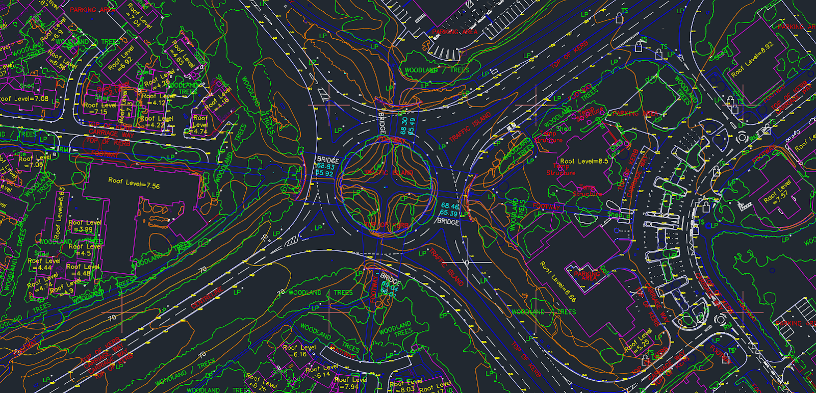
SenCAD of Milton Keynes, where details as small as a lamp post (LP) are quantified
This is achieved using SenSat’s proprietary data capture and processing expertise, which utilises a mix of technologies such as Unmanned Aerial Vehicles (UAVs) during the capture phase. SenSat uses this visual and spatial data to create digital replicas of the real world that are used in large scale construction projects during their planning, design and engineering phases.
The launch of SenCAD is the first of SenSat’s upcoming subscription products on its industry leading software platform, Mapp. The output is incredibly detailed topographical survey data covering areas of previously unattainable scale; produced hundreds of times more quickly and safely, realising massive cost and time efficiencies for clients.
The benefits of using SenCAD:
Speed and accuracy:
SenCAD is unlocking huge time efficiencies for clients by providing them with levels of accuracy at previously unattainable scale and speed. For example, SenSat UAVs capture data 400x more quickly than traditional manual surveying methods, allowing SenSat to produce topographical surveys over areas that previously would not have been able to be surveyed feasibly.
Cost:
High quality CAD drawings at scale are often expensive (/infeasible) to produce as traditional surveying techniques are labour intensive (traversing large scale areas) and logistically complicated and expensive (e.g. closing roads, redistributing traffic). As the UK Department of Transport’s Pathfinder Infrastructure Partner, SenSat has been granted the unique ability to fly their drones 12km beyond the visual line of sight (BVLOS). Therefore, they can aerially capture data over live road and rails, significantly lowering the operational costs. This unlocks tremendous cost savings for clients in the construction and civil infrastructure space. For example, a SenCAD was produced over a 6.4km2 area in Milton Keynes in 2 days – the most detailed survey data of this area in existence – saving over £107,000 in operational costs.
Universal and useable:
Many construction and civil infrastructure clients are forced to use siloed, restricted, decontextualised information during the project lifecycle. SenCADis breaking down these informational barriers by providing clients with a universal 3D topographical CAD survey via its Mapp platform, enabling contextualised, single-source-of truth collaboration. For example, multiple stakeholders in the Bahamas have been collaborating using SenCAD during the planning and design phases of an airport extension of Exuma International Airport.
Safe:
SenSat’s proprietary data capture and processing expertise also improves safety. Their UAVs eliminate the need for significant time-consuming and potentially dangerous ground work required for traditional, laborious surveying methods. Also, a SenCAD can be produced for areas that would have previously been infeasible to safely produce topographical data for, due to difficult terrain and weather conditions.
James Dean, CEO of SenSat says:
“We’re incredibly proud to launch SenCAD out of its initial closed beta, where it’s proved to be a resounding success. SenCAD delivers an orders of magnitude improvement in achievable scale, cost saving, time efficiency, and safety over traditional techniques. It therefore represents a step change in providing universal and useable data in the construction and civil infrastructure space – allowing for better decisions to be made more quickly.
Civil Infrastructure and construction has suffered from a huge ‘information lag’ – information is slow to collect; information is siloed; and information is missing. As the latest subscription product on Mapp, SenCAD is removing these informational constraints; another product that is making simulated sites a reality for over 30 tier one construction clients – information is now fast to collect; information is now universally available; and information is universally useable. Clearly the tremendous value this creates for physical industries that haven’t yet been digitised cannot be understated.”
As a vital component, not only is SenCAD realising the vision of creating simulated sites and realities in the short term, but it is advancing our AI efforts in totally automated object recognition and geo-spatial data production. In other words, it’s a critical and valuable step that is helping us achieve our vision of quantifying the physical world, and then teaching computers to understand this world.”